About FSWidgets Airports
Airports for Android is a handy companion app designed exclusively for flight simulation enthusiasts. For users of FSX, FS2004 or X-Plane (indeed any sim) it provides a quick and easy way to search for world-wide airport,...
Airports for Android is a handy companion app designed exclusively for flight simulation enthusiasts.
For users of FSX, FS2004 or X-Plane (indeed any sim) it provides a quick and easy way to search for world-wide airport, navaid or weather information, and view terminal procedure charts (for the US).
*** IMPORTANT ***
Not for Real Flight Operations - Flight Simulation Use Only!
*** TRIAL VERSION ONLY ***
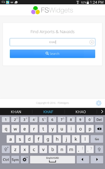
This version of Airports is a trial version only, it contains all the features of the full version but searching is limited to the KSFO San Franciso area only. Please visit fswidgets.com for more information.
To see the demo in action search for airports like:
- San Francisco (KSFO)
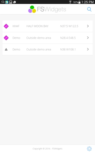
- Half Moon Bay (KHAF)
- Palo Alto (KPAO)
- Metro Oakland (KOAK)
- San Jose (KSJC)
- Buchanan Field (KCCR)
Some of the Navaids in the demo area include:
- San Francisco VOR-DME (SFO)
- Woodside VORTAC (OSI)
- Sausalito VORTAC (SAU)
- San Jose VOR-DME (SJC)
- Kanan NDB (CC)
- Reiga NDB (LV)
The world aviation information database is massive! Downloading and managing it all can be prohibitive, not to mention pointless if you don't use it all. Airports solves this by delivering the data as requested, from the Cloud. Think big data without the big downloads.
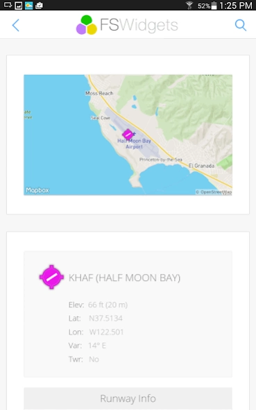
Some airport information services can display data in a way that is overwhelmingly complex and hard to follow. Airports presents the more useful bits of information that flight simulation users rely on in an attractive, easy to read format.
Meteorological conditions are an important consideration for any flight and many flight sim pilots use real-world weather in their simulator. Airports will display the latest METAR (report) or TAF (forecast) if the airfield has those services.
The Airports app includes access to the full set of US TPP charts (Terminal Procedures and Airports). When viewing the information of any US airport, the app will present a list of any applicable SID, STAR, approach and airport diagram charts. The listed items can then be selected to view the PDF right within the app. This feature alone makes Airports a must-have for any sim pilot who flies in the US scenery area.
General Features List:
- Simple to use, attractively designed user interface
- HDPI screen support
- Organises and displays information into easy to read sections
- Search for airports and navaids by name (e.g. San Francisco) or ICAO ident (e.g. KSFO)
- Cutting-edge mapping technologies present an initial overview of the airport or navaid
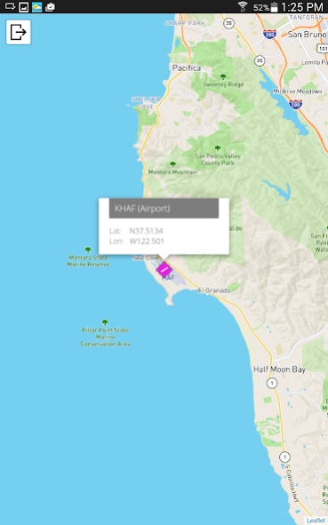
- Select the overview map to see a larger scrolling map for better orientation
- Access to the full collection of US TPP charts (Terminal Procedures and Airports)
- US TPP charts are displayed within the app using the internal PDF reader
- World-wide METAR and TAF weather information
- Tiny app size, no massive data file downloads required
- Data is retrieved as requested, meaning low bandwidth usage
- Powered by Amazon Cloud technologies (60+ content delivery servers world-wide)
General Data Coverage:
- World-wide coverage
- Over 30,000 Airports, Heliports and Seaplane bases
- Over 3,700 VOR Beacons
- Over 7,100 NDB Beacons
- Over 118,00 Intersections and Fixes
Airport Data Details:
- Overview map of airport location and layout
- Larger scrolling map of surrounding area
- Runway information includes identifier, length, width and surface type
- ILS/Localizer details include frequency, identifier, type and heading
- Radio Frequency information
- Latest METAR and TAF weather station reports
- Terminal Procedures and Airport diagrams (for US airports only)
Navaid Data Details:
- Overview map of navaid location
- Larger scrolling map of surrounding area
- Lat/lon, elevation and frequency
Chart Coverage:
- Full set of US TPP charts (Terminal Procedures and Airports)
- Charts displayed via built-in PDF reader
- Access to over 4 GB of PDF charts data
- Over 17,400 individual charts
Previous Versions
Here you can find the changelog of FSWidgets Airports since it was posted on our website on 2016-12-28 00:57:32.
The latest version is 1.0 and it was updated on 2024-04-22 11:58:29. See below the changes in each version.
FSWidgets Airports version 1.0
Updated At: 2016-11-28
Disclaimer
Official Google Play Link
We do not host FSWidgets Airports on our servers. We did not scan it for viruses, adware, spyware or other type of malware. This app is hosted by Google and passed their terms and conditions to be listed there. We recommend caution when installing it.
The Google Play link for FSWidgets Airports is provided to you by apps112.com without any warranties, representations or guarantees of any kind, so access it at your own risk.
If you have questions regarding this particular app contact the publisher directly. For questions about the functionalities of apps112.com contact us.